Claim: Google has removed Palestine from its Google Maps application amid the ongoing Israel-Hamas war.
Fact: The claim is false as Palestine was never labelled on Google Maps. The application’s map only included the Gaza Strip and West Bank, with a dotted grey line indicating their borders.
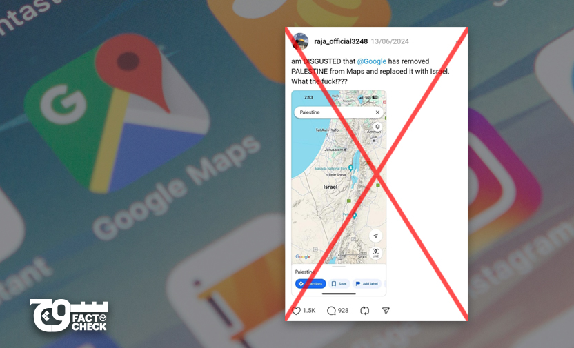
On 14 June 2024, Threads user @raja_official3248 posted (archive) a screenshot of Google Maps showing the northwestern area of the Middle East, with Israel in prominence. The accompanying caption is as follows:
“am DISGUSTED that @Google has removed PALESTINE from Maps and replaced it with Israel. What the fuck!???”
What’s going on in Gaza?
On 7 October 2023, Hamas attacked (archive) a border area of Israel, sparking the ongoing war (archive) in Palestine.
Over 37,300 Palestinians have been killed and more than 85,500 injured, as per an 19 June 2024 update (archive) by the United Nations Office for the Coordination of Humanitarian Affairs (OCHA). At least 1,200 Israelis have been killed and upwards of 5,400 injured, while 120 Israeli hostages remain in captivity.
Ever since the 7 October attack, a flood of misleading, old, and out-of-context pictures, videos, and claims have surfaced in the media.
On 29 December 2023, South Africa invoked (archive) the Genocide Convention — officially the 1948 Convention on the Prevention and Punishment of the Crime of Genocide — against Israel at the International Court of Justice (ICJ), requesting the Court to indicate provisional measures over the war in the Gaza Strip.
History of Palestine
According to Encyclopedia Britannica, Palestine is an area “comprising parts of modern Israel and the Palestinian territories of the Gaza Strip (along the coast of the Mediterranean Sea) and the West Bank (west of the Jordan River)”.
The State of Palestine is recognised by a total of 146 countries, as of June 2024, after Norway, Ireland, and Spain joined the list of nations. Earlier an Ottoman territory, the region was put under the administration of the United Kingdom (UK) by the League of Nations back in 1922, according to the United Nations (UN), which also states:
“All of these [other Ottoman] territories eventually became fully independent States, except Palestine, where in addition to ‘the rendering of administrative assistance and advice’ the British Mandate incorporated the ‘Balfour Declaration’ of 1917, expressing support for ‘the establishment in Palestine of a national home for the Jewish people’. During the Mandate, from 1922 to 1947, large-scale Jewish immigration, mainly from Eastern Europe took place, the numbers swelling in the 1930s with the Nazi persecution. Arab demands for independence and resistance to immigration led to a rebellion in 1937, followed by continuing terrorism and violence from both sides. [The] UK considered various formulas to bring independence to a land ravaged by violence. In 1947, the UK turned the Palestine problem over to the UN.”
The Gaza Strip, West Bank, Old City of Jerusalem, and Golan Heights were captured and occupied by Israel during the 1967 war, according to Encyclopedia Britannica.
In 2013, Google revised the label on the homepage of its Palestinian version, changing it from “Palestinian territories” to “Palestine”.
Fact or Fiction?
When “Palestine” is used as a search word on Google Maps, the application zooms in on the Israel-Palestine region, but does not indicate a region or borders marked as Palestine.
However, the Gaza Strip and West Bank are labelled with dotted lines, highlighting the respective borders, as well as the city of Jerusalem. Israel is labelled clearly, as are the cities of Tel Aviv and Be’er Sheva.
Moreover, when one clicks on any of the cities in the Gaza Strip or West Bank, they are marked as “Palestinian” or appear as located in “Palestine” in the Knowledge Box.
It is important to note that Palestine was never labelled on Google Maps in the first place. During our search, we came across several questions posed to Google Maps Help Community and Google Earth Help Community, some of which can be found here, here, here, here, here, here, here, here, here, here, here, here, here, and here.
Among the responses to one of the questions in the Help Communities was the link to a December 2009 explainer on Google Public Policy Blog, which states: “For each difficult case, we gather a cross-functional group of Googlers including software engineers, product managers, GIS specialists, policy analysts, and geopolitical researchers. This process benefits from the local knowledge and experience of Googlers around the world.”
“We follow a hierarchy of values to inform our depictions of geopolitically sensitive regions,” it states, noting that these include “Google’s mission,” “authoritative references,” and “local expectations.”
Product experts have responded to such queries, not Google representatives. One such response from 2020 reads as follows:
“Google takes a neutral view when it comes to countries, borders, etc; and uses the overall consensus of all nations and how cartographers around the world depict such matters. As the world situation changes, so will Maps.”
We also came across multiple prior investigations into the same claim that emerged during earlier wars and conflicts in Palestine, such as by USA Today, AFP Fact Check, Rappler, and Newsmeter — all of which are accredited by the International Fact-Checking Network (IFCN), of which Soch Fact Check is also a signatory — as well as The Guardian, The Daily Dot, and Misbar.
When the claim emerged back in 2016, the Forum of Palestinian Journalists (FPJS) had issued a statement of condemnation, as reported here by The Palestine Chronicle. Moreover, a Change.org petition made earlier in the same year, titled “GOOGLE: Put Palestine On Your Maps!”, has received over 2.26 million signatures.
In 2016, USA Today wrote, “In an email statement, Google said it doesn’t label the borders because there isn’t international consensus on where the Palestinian borders are located. […] Google said that as part of its efforts to provide a more comprehensive map, it published Street View imagery of the West Bank in 2017, specifically Ramallah, Bethlehem and Jericho.”
The same year, AFP Fact Check wrote, “A spokesperson for Google told AFP by email on July 20, 2020 that it had not recently made changes to borders or territories in the area and has not previously used a label for Palestine on Google Maps. […] The spokesperson directed AFP to two media articles from 2016; this report by technology website Engadget and this report by French newspaper Le Monde. Google has been quoted in both articles as saying Palestine never existed as a label on its mapping services.”
According to The Guardian, The Daily Dot, and The New York Times, Google’s communications manager, Elizabeth Davidoff, said: “There has never been a ‘Palestine’ label on Google Maps, however we discovered a bug that removed the labels for ‘West Bank’ and ‘Gaza Strip’. We’re working quickly to bring these labels back to the area.”
The NYT also added additional comments, writing that Davidoff “said in an email that the company had also never used the label ‘Palestinian territories’ on its maps”.
“The bug affecting the words ‘Gaza Strip’ and ‘West Bank’ persisted on Wednesday, but when Google Maps functions properly both areas are labeled and separated from Israel by a dotted line to signify that their borders are not internationally recognized. The word ‘Palestine’ was recently removed from the local home page of the company’s search engine, but the reason was aesthetic, not political, Ms. Davidoff said. It was taken down to make space for an Olympics-themed Google doodle, a design that sometimes greets users, as were country-specific tag lines for every country in the world. ‘There’s no Google-wide effort to remove Palestine or anything like that,’ Ms. Davidoff said in an email. She said a GIF circulating online (and shared by the activist group Jewish Voice for Peace) that claimed to show a before-and-after image that proved the alleged deletion, was fake,” the publication added.
Separately, Rappler wrote in 2024 that a year earlier, Google told them “that its depiction of Palestine has not changed and that labels for the West Bank and Gaza Strip remain displayed on its worldwide maps”.
According to Google Support, a dotted grey line denotes a treaty boundary, de facto boundary or a disputed boundary.
Soch Fact Check also reviewed other mapping applications, such as Apple Maps, Yandex Maps, and Bing Maps, some of which do, while others do not identify Palestine.
For example, when searching for “Palestine” on Bing Maps, the suggestions lead to the Gaza Strip, homonymous towns, cities, and villages in Texas, Ohio, Arkansas, and Illinois, a hotel address in West Bank, and the Palestine Economic Policy Research Institute (MAS) marked in the “Palestinian Territory, Occupied”. The search term “Palestinian Territory” leads to a United Nations Development Programme (UNDP) address in East Jerusalem.
The Gaza Strip is labelled on Bing Maps, with its respective country marked as Palestine, whereas the status for West Bank reads: “Claimed by the State of Palestine · Partially administered by the Palestinian National Authority in Areas A and B · Under Israeli occupation.”
Apple Maps, on the other hand, only identifies the Palestinian Territories and zooms in on the Israel-Palestine region, with the coordinates 31°54’45.1″N 35°12’16.6″E that point to Ramallah in West Bank.
Meanwhile, Palestine is clearly marked on Yandex Maps, with the coordinates 31°54’01.6″N 35°12’03.7″E that also point to Ramallah in West Bank. The region depicted comprises both the Gaza Strip and West Bank.
Google did not immediately respond to Soch Fact Check’s request for comment; however, this article will be updated upon receiving a response from the company.
This is not the first time Google has come under scrutiny in this regard. In 2014 and 2021, a claim that Google was conducting a survey to identify Israel or Palestine was debunked by Snopes and Misbar, respectively.
Soch Fact Check, therefore, concludes that the claim is false.
Virality
The post by Threads user @raja_official3248 has received over 1,500 likes and close to 1,000 comments. The claim was also shared on the same platform here and here.
Elsewhere, the claim was posted here, here, here, here, and here on Facebook, here, here, here, here, and here on Instagram, and here, here, here, and here on TikTok.
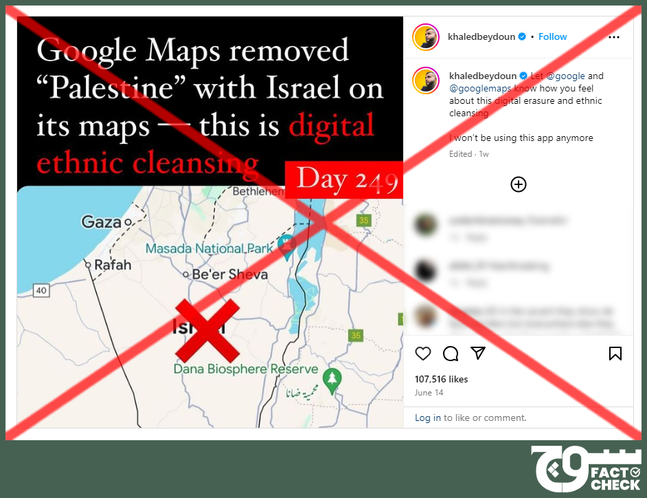
Khaled Beydoun, an author and associate law professor at the Arizona State University’s (ASU) Sandra Day O’Connor College of Law, who often shares false posts, also posted (archive) the claim here on Instagram on 14 June, gaining a whopping 107,516 likes.
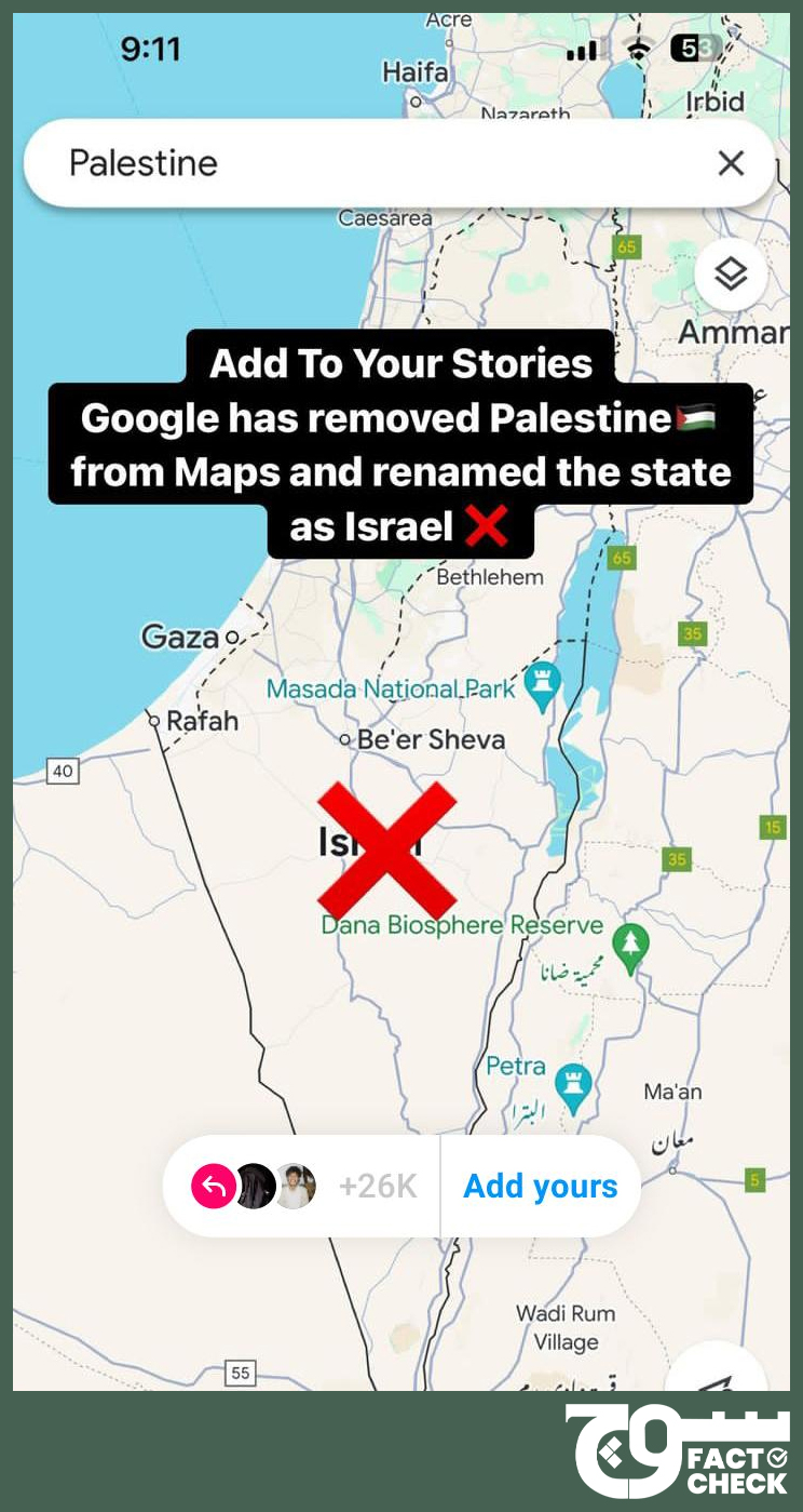
The claim was also reposted hundreds of thousands of times to Instagram stories uploaded under the “Add Yours” prompt, which is an Instagram feature that includes a sticker that, when tapped, “lets anyone contribute to a public story”.
Conclusion: Palestine was never labelled on Google Maps application in the first place, rather only the Gaza Strip and West Bank. The claim is, therefore, false.
Background image in cover photo: William Hook
To appeal against our fact-check, please send an email to appeals@sochfactcheck.com